Fall On Mount Rainier's Wonderland Trail
- Allgreyareas

- Mar 26, 2025
- 13 min read
After many years of hiking at Mount Rainier National Park this last year I have finally found the time and proclivity to embark on the Wonderland Trail.
September 21, 2024
Day 0
A day before my planned start, I arrived at the Carbon River Ranger Station 30 minutes before opening to secure a permit. With a minimal line, permits were secured for an 8-day counterclockwise circumvention
starting at Longmire. The second task of the day was to drop supply buckets. The first bucket was simply handed off at Carbon River Ranger Station upon securing permits. The next stop would be 1 hr 30 mins later on the other side of the mountain at the White River Ranger Station.
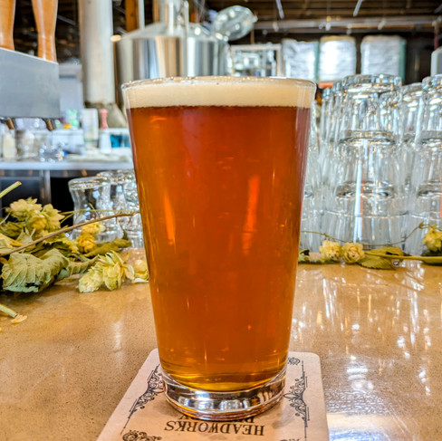
Seeing the mountain reveal itself from behind the clouds left a feeling of disappointment and longing as I drove to exit the park. One of the rare occasions where I did not put foot to bare ground while visiting the park. This feeling was assuaged with a stop in Enumclaw where I partook in the last libation before the start of the trail the following day. Thanks to Headworks Brewing and Pursuit Distilling Co. for filling the void.


September 22, 2024
Day 1 13.5 Miles 4114 Feet Elevation Gain
Longmire to Nickel Creek

After a rather unrestful night in the comfort of home, it was time to head for Longmire. Easy parking at Longmire and on a whim a stop at the Wilderness Information Center at which I was able to make a couple last minute changes. Thank you to whomever cancelled the Summerland Camp group spot last minute that enabled me to obtain it.


Pleasant weather to start from the very mediocre looking trailhead at Longmire. Hiking along the Nisqually river you start to gradually leave the hustle of the park behind as the trail skirts along the road to Paradise to the Cougar Rock Campground where you can start to leave to car tourist world behind with the crossing of the Nisqually River. The trail heads up through the Paradise River Valley and over to Reflection Lakes. From there, the trail heads into Stevens Canyon.


Past Martha Falls the trail has been diverted down to Steven Creek due to a trail washout. Great job by trail crews on the west end of this washout. Future work hopefully coming to the east end soon. Recent wet weather has brought the fungi and moss out for some glorious sights.

Exiting the forest at Box Canyon, I know it's a short climb to Nickel Creek Camp, where the day will end.

September 23, 2024
Day 2 13.1 Miles 4985 Feet Elevation Gain
Nickel Creek to Summerland

Woke up to drizzle and a cold fog as the sky started to brighten through the trees. A quick breakfast and repack to get the day going and to take the chill out of the bones. I was excited for the day as the next camp was Summerland, and I would be into the alpine and out of the trees.

Another climb through the forest to the Cowlitz Divide, where the trees thinned and meadows appeared, sparsely at first, then opening up to basins filled with fall colors. The fog persisted.

Indian Bar was in sight. Always a good spot for a short break and refuel.
With the Indian Bar Shelter in sight it was downhill to this midday goal. A great motivator. Built in 1940 by the Civilian Conservation Corps, this shelter is in relatively good shape thanks to the 2008 remodel.


Starting a break at the shelter, the fog lifted and the clouds dispersed. What great timing.

Looking back on Indian Bar, climbing the ridge into Ohanapecosh Park.

Only 3 miles and 2000 feet higher than Indian Bar, the scenery makes a dramatic change, and one can only embrace the barren alpine scenery with awe and wonder. Snow-free for only a short time, at only 7000 feet, Panhandle Gap starts to give hikers a feel for Mount Rainier's higher reaches. A stiff breeze is sure to come reeling through the gap. Enjoy the views on both sides of the ridge before descending into the meadows of Summerland.


Summerland truly is a special place in the park, and the view from the camp justifies the reservations always being full. Be careful sleeping in the shelter, as you will stay dry, but beware that you will share the space with others who make it their home.


September 24, 2024
Day 3 14.7 Miles 3083 Feet Elevation Gain
Summerland to Glacier Basin


There was a bit of sorrow leaving Summerland, but I felt great after being energized by the view and good weather. Today would be a descent back to the forest and the White River Campground. Down through the meadows into the Fryingpan Creek Drainage, enjoying the views of Goat Island Mountain and Mount Rainier along the way. Back into the forest, skirting the perimeter of Goat Island Mountain along Fryingpan Creek, then continuing along the White River crossing to White River Campground. Being back in one of Mount Rainier's car campgrounds brings me back to reality a bit, as there are once again paved roads and motorized vehicles. Walking down to the White River Ranger Station close by to grab my resupply (hooray for food), I realize the campground is eerily quiet. I come to find out this usually busy campground has already closed for the season.

Not only did I get resupplied, but I also got to meet my sister today, who joined me on the hike to Glacier Basin. Extra acknowledgment to her for packing in homemade tacos up to the camp. It was great to have a good meal. She also provided me with an updated weather report, which called for a storm the next day.

While Glacier Basin is a pretty remarkable destination for those who have a bit of extra drive and energy, you can extend your trip to Mount Ruth (an additional 3.6 miles and 2,741 feet of elevation gain) or head up the Interglacier to Camp Schurman (an additional 5 miles and 3,883 feet of elevation gain).

Although not the standard route, and it adds 5.5 miles and a couple of thousand feet of elevation gain, the trip to Glacier Basin is more than worth the detour. The camp was nearly deserted, with only one other solo camper.

September 25, 2024
Day 4 15.3 Miles 4055 Feet Elevation Gain
Glacier Basin to Mystic Camp

Morning starts with some low clouds and a bit of wind but otherwise fine. Break camp and head back down to the juncture for the Sunrise Trail that will lead to 2nd Burroughs Mountain. Great views looking back, although the increase in clouds is noticeable.


As I hiked up the ridge, the clouds and wind continued to increase. At 7,000 ft, the predicted storm hit, and it was time to break out the rain gear. At 2nd Burroughs, precipitation swapped between hail and snow.

Once down from Burroughs Mountain and onto the Wonderland Trail proper, the hail and wind let up, but the rain seemed to have doubled. The trail turned into a brook while the creeks swelled, making crossing less than ideal and turning downhills slick. Hitting the White River gave some solace as camp was not far off, even as the rain continued its onslaught.


Eventually, Mystic Camp was reached, where I hurried through the selection of camp sites, choosing one of the only remaining sites not completely submerged. Quickly setting up camp and switching out of wet gear and into dry gave some comfort. Dinner was prepared in the vestibule, staying warm in my bag while the rain continued to fall.

September 26, 2024
Day 5 11 Miles 3188 Feet Elevation Gain
Mystic Camp to Cataract Valley Camp
During the night, the rain had stopped. I welcomed the morning with a brightness coming through the trees but also a crispness that numbed the fingers. Now was the time for every hiker's dream: To don the wet clothes from the previous day, break down camp, and get moving before the chill set in.

Not far from camp is Mystic Lake and the Mystic Lake Ranger Station. It was hard not to wonder how comfy I could have been inside that cabin with its supply of firewood on the porch. The original cabin, built in 1931, was completely rebuilt and replaced in 1983.


Apparently, a freeze had come after the rain, and any shallow water remaining on the trail had frozen overnight. Breaking through it was at least a bit of fun.


Rising into Moraine Park, Mount Rainier was showing off its new coat of fresh snow. At this time, I discovered my camera was badly fogging up from condensation. Rather disheartened by this, I decided to ditch the side trip up Moraine Park and along the Carbon Glacier to head instead down the Carbon, where the weather seemed better.

Reaching the nose of the Carbon Glacier, the sky remained clear, but clouds continued to collect on the upper mountain. The mountain is fickle with its weather, so you never know what the next moment will bring.

Reaching the suspension bridge over the Carbon River and with the future of the hike being in the trees, the decision was made to bask in the sun of the riverbed while I prepared lunch and let my gear dry in the welcome solar rays. As for the camera condensation issue, a sunbath eventually cleared the sensor and lens.

With everything dry, I was much rejuvenated. I departed over the Carbon River suspension bridge to continue to camp. Directly across the river, the forest is carpeted with a magical growth of moss.

As this fades, the forest grows darker and more enigmatic. Oftentimes, certain areas of the forest retain personalities. This particular section feels alive with a vibrant life force, welcoming but with an underlying wariness that you are not fully welcome here.


Further on in the old growth further up this ridge lies Cataract Valley Camp. Nestled in the trees with a brook running through for an easy reach of water. Some camp spots still filled with water from the previous night's storm. I secure the secluded spot in the back of the camp.


September 27, 2024
Day 6 13.6 Miles 2654 Elevation Gain
Cataract Valley Camp to South Mowich River Camp
Recharged with a good night's sleep and no rain overnight, I woke to low clouds. Packed and on the trail, I headed up into the sub-alpine zone of Mist Park. Another truly magical place at Mount Rainier. With the recent rains, the greens were even more vibrant than usual, with the fall colors adding to the melody present before me. This is a feast for all the senses.
Beyond the obvious sights, the smells of the trees, plants, fungi, and even the earth itself add to this banquet. Another course comes with the sounds. Silence followed by the gentle breeze of the wind, then a ripple of a creek followed by the staccato call of birds flittering between the trees.

Once rising above the treeline and into Seattle Park, the scenery changes into a stark expanse with low alpine vegetation.

At around 6,300 feet, you reach the top of the ridge. Here, the trail continues down into Spray Park. An alpine side trail here will lead to Echo and Observation Rocks with great views of the Russell Glacier and the south side of Mount Rainier.

Today, Spray Park is enveloped in clouds. Although they obscure the distant views, hiking through the clouds offers its own advantages.

Another of Mount Rainier's famous meadow areas, Spray Park is awash with wildflowers in spring. Fall brings an also impressive array of colors.

One of the largest meadows at Mount Rainier, Spray Park spans 1.5 miles before you sink into the forest on the descent to Mowich Lake.


A stop at Mowich Lake Patrol Cabin yields another stash of food and a break for lunch. Built in 1922, it is one of the oldest Patrol Cabins in the park.
Only another 4 miles yet today as the trail heads again into the forest and down to the Mowich River. Now on the west side of the park, the forest is more lush as most storms roll in from the Pacific, increasing precipitation due to the rain shadow created by the mountain.


After a successful crossing of the river and a somewhat haphazard route finding of the trail, it's a short distance to South Mowich River Camp. One of the least impressive camps so far, it appears to be under constant assault from storms coming up the valley.

September 28, 2024
Day 7 12.47 Miles 3502 Elevation Gain
South Mowich River Camp to Golden Lakes Camp

After breaking camp and navigating the numerous cairns of the South Mowich River, the climb of the next ridge begins. A calm morning with pleasant weather and clear skies. Only 5.7 miles up and along the ridge, passing some nice sub-alpine lakes to Golden Lakes Camp. Nestled on one of the many Golden Lakes sits the Sunset Park Patrol Cabin built in 1922.

Arriving at camp early in the day, I claimed site 5, which sits at the top of the camp and has a beautiful sunset view. After setting up camp and donning a much lighter pack, I headed out on a day trip to Sunset and the Colonnade.

Fall colors are in full swing throughout the meadows. Picking my way up the old trail, I am kept alert by the constant bugling of the elks in rut ringing around me.

What an enjoyable afternoon on the ridge. Mount Rainier spreads out before you with the Mowich and North Puyallup River valleys on either side. Later in the afternoon, clouds rolled in and the wind picked up. Time to leave the solitude of the ridge and head back to camp.


Heading back down along Swift Creek to get a bit of a different view and chanced upon a stray tracking collar. Not your everyday find on a hike, so decided to pack it out to the patrol cabin.

Back at camp, there was enough time to restock water and make a meal before enjoying a nice sunset from camp.


September 29, 2024
Day 8 26.8 Miles 6363 Elevation Gain
Golden Lakes to Longmire
Woke up to a beautiful morning, albeit with a bit of frost on the ground. Great views today heading across the ridge and into the woods of the North Puyallup River drainage. Back up Klapatche Ridge to Klapatche Park Camp, making great time and arriving way before lunch.

One of the best camp views in the park, Klapatche park camp is a great area to explore with Aurora Peak, Saint Andrews Park and Lake, Andrew Peak, and Tokaloo Rock and Spire all doable as hikes from the camp.

Originally planning to spend the night at Klapatche Park Camp, seeing as the hour was early and I had stayed there three weeks prior, I decided to carry on for the day. A short hike to St. Andrews Lake where I refilled water and had the pleasant surprise of having the lake to myself, as the previous trip it was packed with hikers bellowing and generally raising a ruckus while swimming in the only close water supply.

Continuing on through St. Andrews Park, looking to the west, the mood of the pristine park is soured a bit by the sight of logging below Puyallup Point, just outside the park boundary.


Down the ridge from St. Andrews is the South Puyallup River and the South Puyallup River Camp. Heavy with silt and debris, the Puyallup flows as murky as the other glacier rivers in the park. Don't pass up the short detour to the Andesite Columns next to Puyallup River Camp.


Relatively early in the day still and only 6.2 miles to the next camp, I power on.
Once again up another ridge. A mostly rocky path up to Emerald Ridge where a known great view awaits. With the copper hues of the Tahoma Glacier terminus, the Hummock and Glacier Island, let alone Mt. Rainier itself, Emerald Ridge dishes out one of the most underrated views in the park. A special bonus is the lack of crowds and a healthy population of marmots. A short hike/scramble up the Hummock gives an unobstructed view of the Tahoma Glacier.


The path continues along the Tahoma Creek Drainage to reach the second suspension bridge on the Wonderland Trail, then ascends once more into the magnificent meadows of Indian Henry's Hunting Ground. Notable side excursions in this area include Mirror Lakes, Pyramid Peak, and Copper and Iron Mountain. Make sure to visit Indian Henry's Patrol Cabin just off the trail. It's the park's oldest patrol cabin, constructed in 1915.


Hitting Indian Henry's just before sunset, I soon put on the headlamp and kept booking down the trail toward the next camp. Hitting a deserted Devils Dream Camp, I realized that I still had an excess of energy, and it was only 5.2 miles back to Longmire. The decision was made to keep heading down the trail. There is something truly serene about night hiking. Easy going until the crossing of Kautz Creek. With the crossing washed out recently, navigating was a bit of a hassle but nothing insurmountable. Smelling the campfires from the Cougar Rock Campground, I knew my goal of Longmire wasn't far off. Rolling in at 10:30 pm, celebrating the end of the journey with the quiet of an empty parking lot.

A shoutout to all the rangers and volunteers that keep this park running. Despite constant storms, harsh winters, and overuse in some areas, they continue to do their best to make this a park I want to return to again and again.


Comments